

Want to share your content on R-bloggers? click here if you have a blog, or here if you don't.
We have all seen colourful signposts with great cities and their distances – how far each is from this current standpoint.

And fundamental question is, how correct these distances are? Or even, one should ask, how honest a particular signpost is, regarding the current standpoint.
So let’s put this utterly most fundamental question to the test 

Image stumbling upon the post and wanted to check if this post is really relevant for this location. It can be a photo from other side of the world, hanging in the lobby of your holiday hotel
The R code iterates through each city, finds matching points (where all circles meet) and searches for the nearest location. It uses OpenStreetMap (short: OSM) to extract all the geolocations and looks for possible intersections of all points
geocode_city <- function(city_name) {

  url <- modify_url(
    "https://nominatim.openstreetmap.org/search",
    query = list(
      q       = city_name,
      format  = "json",
      limit   = 1
    )
  )

  resp <- tryCatch(
    GET(url, user_agent("PointingSignFinder/1.0 (R script)")),
     error = function(e) {
       cat(" Error on endpoint")
       return(NULL)
     }
  )

  if (is.null(resp) || http_error(resp)) {
    cat(" Error on http\n")
    return(NULL)
  }

  result <- fromJSON(content(resp, as = "text", encoding = "UTF-8"))

  if (length(result) == 0) {
    cat("Error on result")
    return(NULL)
  }

  lat <- as.numeric(result$lat[1])
  lon <- as.numeric(result$lon[1])
  cat(sprintf(" found: %.4f°, %.4f°\n", lat, lon))

  Sys.sleep(1.1)

  list(lat = lat, lon = lon, display_name = result$display_name[1])
}


sign_location_finder <- function(cities,
                                 distances,
                                 tolerance = 50,
                                 coarse_res = 0.2,
                                 fine_res   = 0.02,
                                 nearby_radius = 200,
                                 nearby_min_pop = 100000) {

  stopifnot(length(cities) == length(distances))
  stopifnot(length(cities) >= 2)

  cat("Step 1: Geocoding cities\n")
  coords <- lapply(cities, geocode_city)

  failed <- which(sapply(coords, is.null))
  if (length(failed) > 0) {
    stop(sprintf("Location not founc: %s", paste(cities[failed], collapse = ", ")))
  }

  sign_data <- data.frame(
    city    = cities,
    lat     = sapply(coords, `[[`, "lat"),
    lon     = sapply(coords, `[[`, "lon"),
    dist_km = distances
  )


print(sign_data[, c("city", "lat", "lon", "dist_km")])

max_dist_deg <- max(sign_data$dist_km) / 111
lat_min <- min(sign_data$lat) - max_dist_deg - 5
lat_max <- max(sign_data$lat) + max_dist_deg + 5
lon_min <- min(sign_data$lon) - max_dist_deg * 2 - 5
lon_max <- max(sign_data$lon) + max_dist_deg * 2 + 5


lat_min <- max(lat_min, -85)
lat_max <- min(lat_max,  85)
lon_min <- max(lon_min, -180)
lon_max <- min(lon_max,  180)

cat(sprintf("\nStep 2: Search bounding box: lat [%.1f, %.1f], lon [%.1f, %.1f]\n",
              lat_min, lat_max, lon_min, lon_max))


  score_point <- function(plat, plon) {
    diffs <- sapply(seq_len(nrow(sign_data)), function(i) {
      d <- distHaversine(
        c(plon, plat),
        c(sign_data$lon[i], sign_data$lat[i])
      ) / 1000
      abs(d - sign_data$dist_km[i])
    })
    max(diffs)
  }


  cat(sprintf("\nStep 3: Search the grid (%.2f° resolution)...\n", coarse_res))
  grid <- expand.grid(
    lat = seq(lat_min, lat_max, by = coarse_res),
    lon = seq(lon_min, lon_max, by = coarse_res)
  )
  cat(sprintf("Checking %d grid points...\n", nrow(grid)))
  grid$score <- mapply(score_point, grid$lat, grid$lon)

  candidates <- grid[grid$score <= tolerance, ]
  cat(sprintf(" Found %d candidate cells within ±%d km tolerance.\n",
              nrow(candidates), tolerance))

  coarse_best <- grid[which.min(grid$score), ]

  fine_grid <- expand.grid(
    lat = seq(coarse_best$lat - 1, coarse_best$lat + 1, by = fine_res),
    lon = seq(coarse_best$lon - 1, coarse_best$lon + 1, by = fine_res)
  )
  fine_grid$score <- mapply(score_point, fine_grid$lat, fine_grid$lon)
  best <- fine_grid[which.min(fine_grid$score), ]

  cat(sprintf("\n>>> Estimated  locations:\n"))
  cat(sprintf("    Latitude  : %.4f°\n", best$lat))
  cat(sprintf("    Longitude : %.4f°\n", best$lon))
  cat(sprintf("    Max error : ±%.1f km\n", best$score))
  cat(sprintf("    Google Maps: https://www.google.com/maps?q=%.4f,%.4f\n", best$lat, best$lon))

  cat(sprintf("\nStep 5: Nearby cities (within %d km, pop > %s)...\n",
              nearby_radius, format(nearby_min_pop, big.mark = ",")))

  world_cities <- world.cities
  nearby <- world_cities |>
    filter(pop > nearby_min_pop) |>
    mutate(
      dist_to_sign = distHaversine(
        cbind(long, lat),
        c(best$lon, best$lat)
      ) / 1000
    ) |>
    filter(dist_to_sign <= nearby_radius) |>
    arrange(dist_to_sign) |>
    select(name, country.etc, lat, long, pop, dist_to_sign) |>
    head(10)

  if (nrow(nearby) > 0) {
    cat("\n  Cities found:\n")
    print(nearby, digits = 4)
    cat(sprintf("\n  Nearest: %s, %s (%.1f km away)\n",
                nearby$name[1], nearby$country.etc[1], nearby$dist_to_sign[1]))
  } else {
    cat("No major locations found in vicinity!")
  }


}
So now, that we understand the useless problem, we can put this to the test
# sample 2 - real with correct distances calculater from# https://www.distancefromto.net/ "air distance"# result must be Ljubljana, Sloveniaresult <- sign_location_finder( cities = c("Koper", "Celje", "Maribor", "Kranj"), distances = c(83, 61, 104, 24), tolerance = 20)
In this case I have entered the correct air distances and there should be a location present – which is capital of Slovenia – Ljubljana.
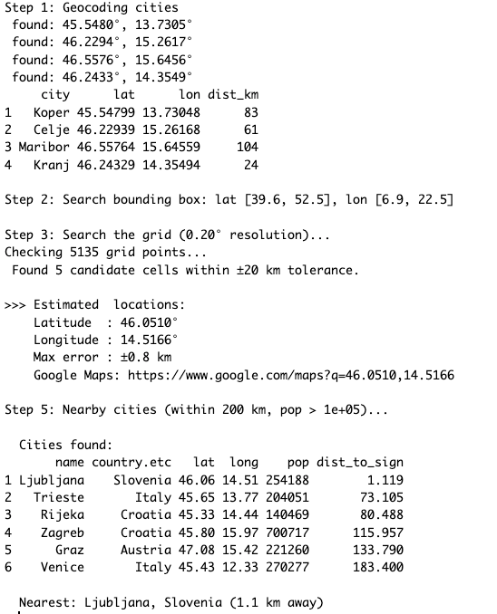
I have inserted the real values of air distances between Ljubljana all all four cities: Koper, Celje, Maribor, Kranj using air distance calculator.
And this where the circles should meet
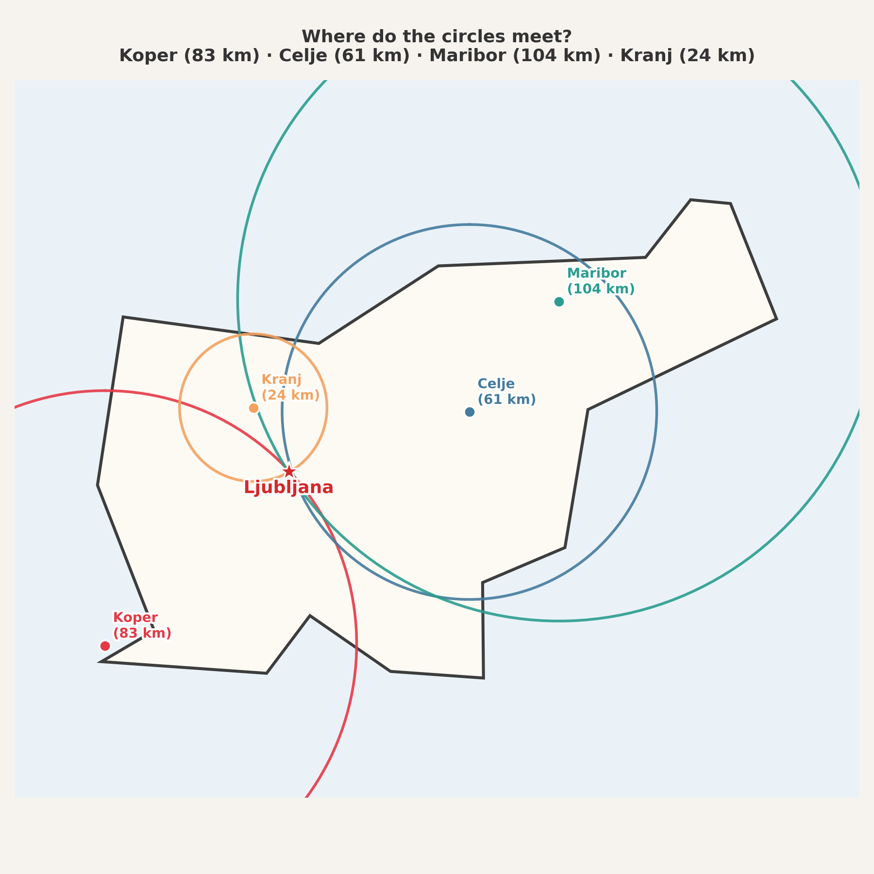
So if you are enjoying your vacation and you stumble upon a sign, check it and let me know, if it corresponds to your location of not
As always, the complete code is available on GitHub in Useless_R_function repository and the file Honest_geographical_location_signposts.R is here.
Check the repository for future updates!
Stay healthy, hydrated and happy R-coding!
R-bloggers.com offers daily e-mail updates about R news and tutorials about learning R and many other topics. Click here if you're looking to post or find an R/data-science job.
Want to share your content on R-bloggers? click here if you have a blog, or here if you don't.